Blogger Widgets
Home Expenses Plant Guides Mine Downloads

Inspiration has hit me

Sunday, March 17, 2013  at 3:34 PM 0 comments
Whilst browsing the internet on more ideas for revegetating the Tenterfield Creek, and trying to find ways to prevent seedlings from being washed away in floods I came across this article: http://www.wetlandcare.com.au/index.php/our-work/successful-projects/wetland-restoration-and-rehabilitation/northern-nsw-upper-tributaries-rehabilitation-project/

It mentioned how they planted seedlings deeper than normal, almost burying the entire seedling into the ground. Apparently this technique, called "The long stemmed planting technique" has a really high success rate of seedlings not being washed away in times of floods. The next time I buy seedlings I will try it out.

If it doesn't work then I will be at a loss on how to revegetate the Tenterfield Creek successfully. But I have to keep my hopes up. Something has to work!!!

Water still flowing into creek

Friday, March 8, 2013  at 10:57 PM 0 comments
It has been a few days since the rain has stopped but when I was taking photos of the creek yesterday I noticed the creek was still flowing. The water level was up pretty high still and water is still flowing over the top of our other neighbour's driveway. The water is coming down from MT. McKenzie still. During even a major flood this does not happen as the water subsides quickly.

Here are a few pics from yesterday of the creek.

After view: Creek from the Douglas Street bridge looking south.
Australian Wood Ducks in the foreground.
When I enlarged the image above I noticed how high the sand had been backfilled on that corner. As you can see the sand is much higher in this area than any other point lower down near the water itself. Also the slope of the creek bank has been altered from a steep slope to a gradual decline then it flattens out near the water. There was a build up of sand in the immediate area on that corner beforehand but nothing like it is now. The forces of nature needed to create such a restructure of the creek and bank is beyond the power of us mere mortals.

Before view: photo taken 28 January 2013. Before all the sand and rock
debris was relocated along the Tenterfield Creek.
Where one of the seedlings was planted.
As this section of the creek has altered since the last flood occurred I cannot tell if these bamboo sticks were where the remaining gum tree seedling was planted or whether it was where the bush was planted. They were both planted within 5 feet of each other. I was surprised the bamboo sticks were still in the ground.

Water still flowing across the driveway.
Yesterday's pic of the water still flowing into the creek at the back of my neighbour Carol's property. When overflowing the water rushes over this driveway. I am surprised to still see water going over the driveway. The water on the other side of the driveway is where the water comes from MT. McKenzie which you can see in the distance behind the gum trees at centre and centre left of this photo.

Close up of the water flowing across driveway.
Currently it is still trying to rain. The sun came out today making me believe all the clouds were clearing up but apparently not as it is overcast again and sort of raining as I write this post. I very much doubt that the creek's water level is going to drop any time soon.

Seedling death toll is grim

  at 7:57 PM 0 comments
Yesterday I was able to do a death toll of all the seedlings I had planted in the creek or within 6 feet of it. Out of the 13 seedlings I planted within this zone only 2 have survived. The 2 survivors are Flooded Gums which have not escaped injury. They have been bent over and slightly uprooted from the strong current and rocks washed over them. Their future survival is not promising.

On a further note, the island which was forming in the middle of the creek that I had planted 2 gum trees and a bush has been destroyed by this last flood. I discovered a self-seeded gum tree seedling had also started growing on that island but it was also washed away.

The left view of what used to be the island.
Centre view of what used to be the island.
Right view of what used to be the island.

Surprise, surprise. Guess what's growing in what used to be the island? A Melaleuca! The Melaleuca is just off centre toward the top of this third photo above. It's branches are curving up and to the left, and are a yellowish green colour. The Melaleuca in this photo was in the direct path of the flood water's flow and current, unprotected by boulders yet it somehow survived when all else was washed away. This Melaleuca must has some super strong roots to not have been uprooted by the flood. It looks like it will survive despite it being fairly young still.

My 2 Flooded Gums again. Notice the plant right on the water's edge
in the background - this side of the water?

I'm not entirely sure what species of plant the dark green leafed plant is but I believe it might be some sort of Jasmine. This plant has survived flood after flood for years on end, including the worst flood Tenterfield had seen in 60 years. And it is still there minus some leaves, stems and flowers. It just looks like it has been moved with a lawn mower actually. This "Jasmine" is actually growing in the creek itself, in the creek's water. It is also growing on the west side of one of the bends in the creek.

There were a few other specimens of this plant, seedlings of this main plant I'm guessing, but they were washed away or buried underneath sand/rock debris from this last flood.

This "Jasmine" is a tough plant to kill via flooding. I've always wanted to get cuttings of this plant to see if I can establish more of them along the west and south sides of the creek banks. The Jasmine is even tougher to wash out than the reeds that grow in the creek.

Myself (red tshirt), my daughter and neighbour's dog. Photo by Daniel C. Hardy.
Reeds and grasses where the creek's water normally is. Photo taken in
first week of December 2012.
When a major flood comes along all but a few mature reeds are washed away by flood waters. The grasses usually are the only things left in the creek. Over the course of several years of flooding the reeds and grasses have all but disappeared from within the creek itself. They always seem to grow back though, as new seedlings emerge to replace the mature plants that get washed away.

Nature is always trying to revegetate the creek with what flora is currently available in the creek itself. However, with the last 3 floods it has endured there is very little flora left that could possibly survive. Seeds get washed away so too do the seedlings. It has become a fight against nature now, to help the vegetation (native) to survive and prosper. It is the young seedlings that need all the attention, not what I could possibly do to revegetate the creek. Growing Melaleucas in between boulders or in cracks between boulders is now sounding not as silly as when I first came up with that idea (about a week ago).

Fighting the forces of nature

Monday, March 4, 2013  at 3:57 PM 0 comments
In the passed 3 months the Tenterfield Creek has undergone a major change to it's layout by 2 minor and 1 semi major floods. In all the time I have been watching this section of the creek never have I seen so much change happening in such a short period of time. Ironically, the placement of sand and rocks has been only on the topside of the creek (north and west sides) - the same sides of the creek in which I have been planting trees and shrubs.

It may be a coincidence but it looks like mother nature is working with me to rebuild the creek and to transform it into something that prevents erosion on my neighbour Carols side of the creek. Its like nature is back building the creek bank for me. I can't explain this any other way but I'm sure a scientist could.

The downside to all of this is I have lost quite a few tree and shrub seedlings to the floods these passed few months. I have not done a seedling dead toll of this last flood but will do so when the water subsides. The previous flood saw the death of 10 seedlings.

The dumping of the sand occurred in just a few days during the peak of the flood, around Friday, the 1st March. There is no possible way any human could shift this amount of sand with their bare hands in just a few days and the intricate details of the placement of the sand is marvellous.

This last flood has created sand dunes in places where the Dam water comes into the creek, and another sandbank that has turned into a channel for the water coming from a westerly direction which curves into the stretch of water which also runs toward the Douglas Street bridge. This formation where the 2 sections merge suspiciously looks like the creation of a river or a river's mouth.

It is hard to describe in mere words what nature has done to the creek recently so I will add some photos as a visual aid. The aftermath of this last flood has to be seen to be believed. Photos can only do so much justice to the marvels of nature of this flood.

As far as I am aware, no animals were harmed in the making of this flood-induced reconstruction of the landscape.

The sand buildup on the left was not there before. The ground used to dramatically slope down half
way then flatten off to the water's edge. It was all covered in grass.

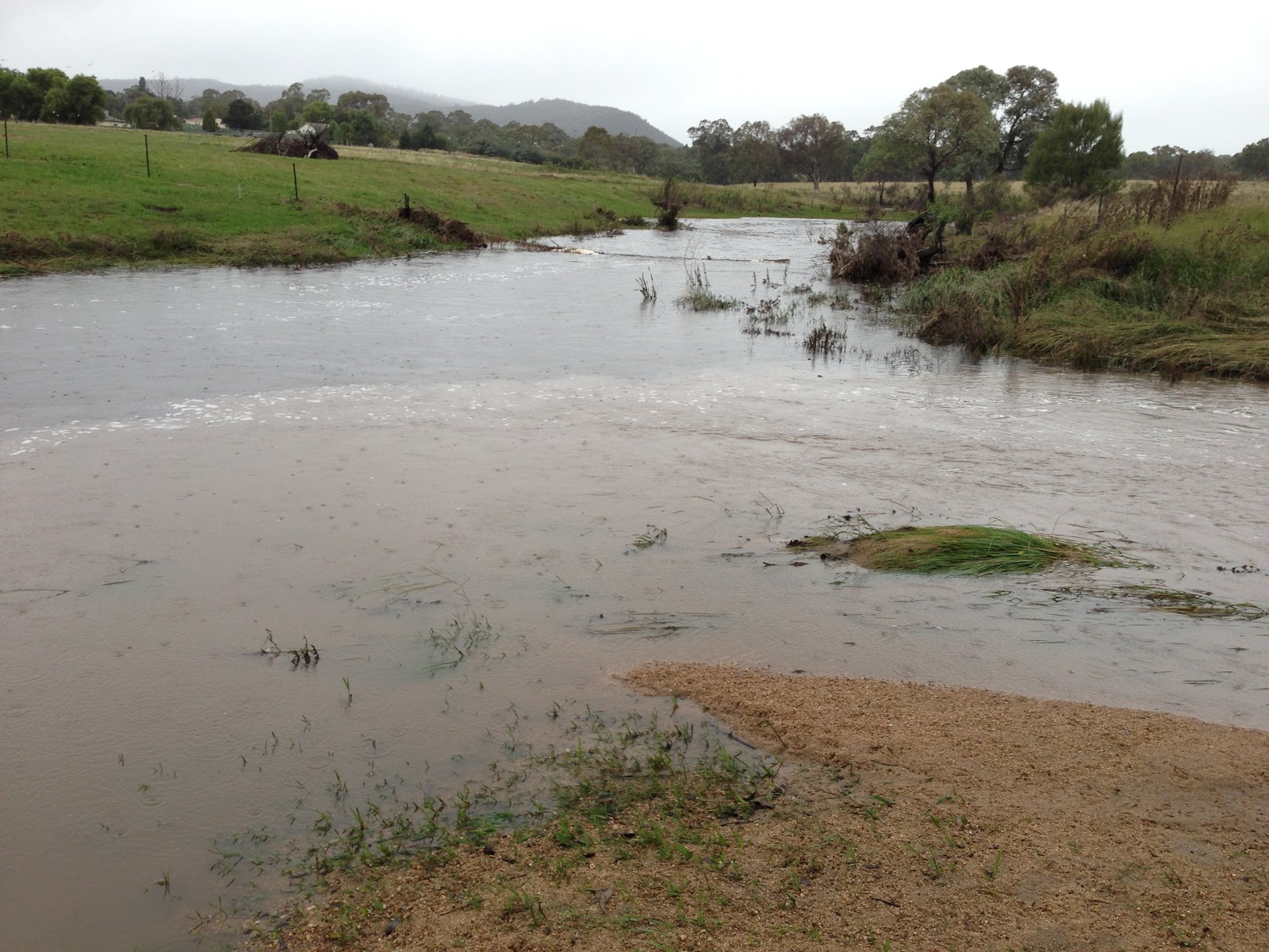
A huge amount of sand has been dumped on this bend of the creek. The water flows in a curve (from the right in this image) now as it merges into the flow of the water coming from the Dam (center top).

This particular section is interesting. Where the water meets the trees on the left, a dangerous swell now
has formed in that area. The creek used to bend here but it looks like it is forming a straight line.

This area used to be severely eroded by previous flood waters, but nature has backfilled this entire
section with sand and rocks, creating a minature beach.

Looking west you can see the path of rocks that had been swept into the area by the flood. Two of my Flooded Gum trees are barely visible near the top of the photo.

The two Flooded Gums hanging in there, after numerous floods. Bent over by the force of water, and probably by the rocks rolling them over as they were swept through the area.

A Melaleuca survivor. I didn't know this fellow was even there. It survived by growing behind a large boulder, protected from the severity of any flood's current.

Boulders that were disturbed by Council workers last year seem to be still in place. The ground around them may have been washed away though.

Topsoil, plants, and fencing has been removed by the power of this minor flood. The debris ended up where I am trying to plant trees along the creek.

Observing through photographs, the strongest native plants to survive these monor, and major, floods are Melaleucas. They seem to be conviently placed in pockets where their roots are not fully exposed to the strongest currents that a flood creates.

Keeping this is mind, I have decided to plant gum trees and Meleleucas in small pockets that will also be protected from the stronger currents. I believe that this might be the only way to get the seedlings to survive future floodings. With their guaranteed survival in the creek, I will be able to add future plants in similiar locations.

However, the main problem will be revegetating the main stretch of the creek where the 2 water flows merge and flow together. I think revegetating the top of the creek bank on the west side is a possible starting point, as that is where the sand is back building - along that sloped area. I'll have to use any existing plants as a barrier to the strong currents, though, which is very sparse in this area. In the main section of the creek there are a few willow tree stumps which I will also use as protection for more gum trees and Melaleucas. If I can get any of these 2 species to establish whilst being shielded from the strong current of the water, I will be extremely happy.

Revegetating the creek is more complicated that I first thought. It has to be a slow process, a process that will allow nature to create whatever it is creating with the creek, be it river or river mouth. Moving the future seedlings to locations directly in the path of the strongest of water currents is a top priority now. Nature has shown me where trees and bushes are surving during floods - I only need to manually do the same and in several years time flora will begin to florish as their roots will help bind the soil together to help future seedlings' roots bind amongst their roots.

It's simple logic really but complicated and disheartening by man's desires to revegate a creek without thinking of how or where plants survive in the extremes of floods.

My next task - to build a foundation network of plants whose roots will merge together in sheltered pockets of the creek.
 
Copyright © 2012 Tenterfield's Bangor Rainforest which is Powered by Blogger
Designed by UFO Designs by Shirley E. Hardy | Bloggerized by Blogging Tutorials for everyone

SitemapDisclaimerContact meInvite friendsGuestbookAbout this site

This is a blog about the man-made construction of the privately owned Bangor Rainforest in Tenterfield, NSW Australia.

Scroll to Bottom Back To Top